Monday, March 28, 2011

North Island Last Day

Sunday 27th March 20.5 kms 6 hrs

A wandering track took me up into the cloud again on my way to Mt Kaukau and then along the Skyline Walkway in what Wellingtonians would call a light breeze - others would just say it was quite windy. Then down into the western suburbs of Ngaio and Wadestown through some charming parks and streets to the Botanic Gardens. But learning quickly that walking around Wellington involves very few level stretches.

The Northern Walkway route took me to the Botanic Gardens and the top of the Cable Car, and the City to Sea Walkway then took me without too many hitches down to the southern coast at Island Bay - more hills, more parks, and then just when it should give up and go down to the sea, it zigzagged up a final hill and along a ridge line just at the same time that it really did rain for a while.

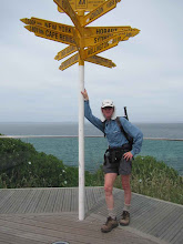
But there it was - the south coast of the North Island and so I was soon down onto a pleasant walk around The Esplanade to the official end of Te Araroa North Island in the main settlement at Island Bay. Great sea and sky views, no southerly wind blasting me, so what a great way to finish my North Island travels. In the picture is Taputeranga Island just off the coast at Island Bay.

Queen Elizabeth Park to the Wellington hills

Saturday 26th March 47.8 kms 8.75 hrs

Off on a drizzly morning down the coastal side of Queen Elizabeth Park as the good metalled track wandered up and down and around the sandhills. Leaving the park the trail followed the coastal road through Paekakariki to take me onto the section of SH1 that is almost in the sea. Still drizzly at times, until after I had reached Pukerua Bay and climbed up and over the hill there.

Then the trail took me up further onto a high point with some great views, especially as I was coming down into Plimmerton - looking down along Porirua Harbour in a splendid mixed sunny and cloudy landscape. So down to the sea again and around through Mana and Paremata to a lunch stop at a pleasant Aotea Lagoon - so close to a busy road, but hidden away so that you would not know it is there.

Then on through Porirua itself and up into the hills behind - hundreds of steps took me up through and out of the bush, leading to Colonial Knob. I must return there when there is no cloud about, since then the views would be superb. So down through a steep and slippery section of pine trees to Ohariu Valley - along the road to the end of Rifle Range Rd ready for tomorrow's final north island section. Horse lovers' heaven around here.

Otaki Forks to Queen Elizabeth Park

Friday 25th March 53 km 9.25 hrs

Back to Otaki Forks by the swingbridge to walk out along the road, past the historic stone fences, and through the shady Totara Reserve overhanging the road. Around and into the hills again on Mangaone North Rd, and then onto the Mangaone Walkway. Delayed for a while because of ripe blackberries, then up and over a low saddle, into an open grassy area, and then back into some pleasant bush, all on easy tracks.

More roads down to Waikanae, then onto the walkway following the meandering Waikanae Stream almost all the way to the coast. Then onto the beach at Paraparaumu, with Kapiti Island looming close by, and views of the South Island in the distance. So down the coast, sometimes on the beach, sometimes on the coastal road until I arrived at the north end of Queen Elizabeth Park. A calm sea, minimal wind, and very pleasant walking on what is often a very windswept coastline.

Friday, March 4, 2011

Tararua Tops Day 4

Friday 4th March 10kms 4.5 hours

Gusty winds even in the Otaki valley, so pleased to be walking out today. A walk through at times very dark bush alogside the Otaki River, before walking up alongside a side stream into an area called the Plateau. The expected light rain started at that point, so nothing to cause me to dawdle along the way.

Then down another small stream, crossing it many times, and at times in the stream bed itself. Then eventually onto a track using an old logging tramway, so from there the going was mostly easier, barring one more steep climb to go over the top of a huge slip. So arrived at the Otaki Forks carpark just before midday.

I am thrilled that in the last few days I had now completed the most difficult section of Te Araroa North Island, and needing to be back in Auckland this weekend, it is time to halt my Te Araroa wanderings for the moment, and find some time for the remaining few days down to Wellington soon.

Tararua Tops Day 3

Thursday 3rd March 21 kms 10 hrs 45 mins Ascent 2130m Descent 2760m

An early start from Te Matawai hut had me walking through and then above the early morning cloud to the junction near Pukematawai and from there it was a regular up and down along the Main Ridge track, that runs on a ridge along the middle of the Tararuas. So past Butcher Knob, Dracophyllum Knob / Hut (3.5 hrs), Puketoro, Kelleher, and then up to Nicholls (3 hrs). From there seriously on open ridgeline to the top of Mt Crawford.

From there views in all directions - Ruapehu, Mt Taranaki, the Wairarapa, Kapiti Island, and peaks in the northern South Island. And of course closer to hand the dramatic peaks and deep valleys of the Tararuas in all directions. I have never been here before, so really thrilled to be here on a good day. Most of the time you are walking along the top of a fairly narrow ridge, and very strong winds are frequent, so it is just not possible if the weather is bad.

Then down, down, down (arrggh!) to the Otaki River and the warm Waitewaewae hut. Ideally this day's section should be done in 1.5 days, but time and weather forecasts meant that it was prudent to have one long day and get off the tops. In the event, given Froday's weather, that was a correct decision - I could easily have been stuck up in another hut for another couple of nights waiting for the wind to go down. Anyway - a really trmemendous, if long, day.

Tararua Tops Day 2

Wednesday 2nd March 0kms 0hrs

As per all the weather forecasts, today had two options - Plan A - stay put and wait for tomorrow, or Plan B - get a half day break in the bad weather and move on to the next hut. In the event at 5.45, and at 7.30 I went back to my sleeping bag, and the weather did not improve until the evening. Tomorrow will be a longer day as a result

Tararua Tops Day 1

Tuesday 1st March 16kms 6 hrs 45 mins

From Poads Rd near Levin to Te Matawai Hut. As the route directions say - ascent 1500m, descnt800m. Starting with a short walk across farmland, and then into the Tararua bush. A steady climb up and out of the bush to Waiopehu Hut (3.5 hrs). That has a great view out to the west, but not today as I was now in drippy cloud.

From there up some more to some peaks over 1000m, followed by a significant descent to Butchers Saddle before the final climb to Te Matawai Hut. Not many Te Araroa walkers in the hut books ... this section can only be done if you are really keen and the weather is in your favour.